
November 16, 2012
Oasis Palms RV Park
Thermal, CA
We got an early start for our trip to Joshua Tree
National Park. When I tried getting
directions from the GPS I was unable to because I didn’t have a physical
address for the park and it did not come up under nearby ”attractions” because
we were too far away from the park for the GPS to locate it. I
printed MapQuest directions that took us on the very scenic route through Box
Canyon where we did not encounter another car for 20 miles. After crossing over Highway 10 we stopped at
the entrance to the park and took our customary picture in front of the
sign. (We have 8 other pictures of us
in front of signs for National Parks)


Our first stop was at the Cottonwood Visitor Center
where I stamped my passport and got maps that described the history and wonder
that is Joshua Tree National Park. The Joshua
tree is a member of the Agave family.
Legend has it that the Mormon immigrants, who made their way across the
Colorado River, named the tree after Joshua, the biblical figure because the
outstretched limbs appeared to be in supplication guiding them westward.


Before leaving the center we asked which hike the ranger
would take if he only had time for one and he said he would do Ryan
Mountain.
We took a ride through the nearby Cottonwood Campground
to see if it would accommodate our rig. Most of the sites are for smaller RVs but
there were a few that we thought we could fit in so we are considering staying
at the campground on our way to Arizona.
There are restrooms, an area to take on water and a dump station but no
electricity. We could stay 2-3 days
using our generator to charge the battery on the rig.
Continuing on Pinto Basin Road, the main thoroughfare
through the park, we stopped at the Cholla (pronounced choy-ya) Cactus Garden
and walked the short nature trail wounding our way around the spinney
plants.


We heeded the signs warning against touching or getting too close to the cholla cactus because the spines could penetrate the flesh and are difficult to extract.


We heeded the signs warning against touching or getting too close to the cholla cactus because the spines could penetrate the flesh and are difficult to extract.


Monte spotted a tarantula crossing the road and had to
stop to take pictures.


The weather was absolutely perfect for being in the desert as it was a little overcast giving us protection from the sun but the patches of blue sky poking through the clouds were spectacular against the majestic mountains in the distance. We stopped at a few exhibit viewpoints along the way but passed several up because we wanted to make sure we had enough daylight to ascend and descend the mountain.

We also checked out a few other campgrounds in the park but the majority of them would be too small for our rig.
We arrived at the parking lot at Ryan Mountain and
geared up. We had our hydration packs
with us that hold 64 ounces of water as well as our trekking poles. A couple went up ahead of us without any
water. I don’t know how they managed the
hike without getting dehydrated because I ended up drinking almost my entire
bladder full by the time we got back to the car three and a half hours later.


The sign at the start of the trail for Ryan Mountain
warned to take plenty of water and to allow 2-3 hours for the 3 mile hike. It took us 2 hours to reach the 5461 foot
summit because I had to stop every ten feet or so to catch my breath. I have to admit the thought of giving up
crossed my mind a couple of times but as people kept passing us up I reminded
myself that it was not a contest to see who gets to the top first. As we were climbing it was difficult to see
how much further it was to the top and every time I thought we were close and
the end had to be around the bend, it wasn’t.
BUT finally we reached the summit and I really felt a sense of accomplishment.


 We spotted a geocache and left a message


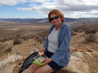


We had lunch and then explored the summit where we found
a big pile of rocks. I spotted a metal
lunchbox and when I opened it was delighted to discover it was a geo cache
containing among other thing some notes, a coin, and a small bottle of hand
sanitizer. I looked in my backpack to
see what I could leave and the only thing I felt I wouldn’t miss was my San
Francisco cable car boarding pass. So
after putting a message on it and the date, I deposited it in the box and
returned it to the rock pile making sure it could be seen for the next geo
cache seeker.
Our descent took less than one hour. It was much easier to breathe on the trip
down but much harder on the knees. I’m
really glad that I had my trekking poles because without them I am sure that at
some point I would have taken a fall or twisted an ankle.


Back at the car, we eagerly changed out of our hiking
boots and, having worked up an appetite, wolfed down some animal crackers and
an orange. On the way out of the park we
passed a bunch of rock climbers.


The rocks are huge and each one unique so it is easy to see why they would be attracted to the rock formations. Because we had traveled so far north in the park, the GPS had us taking a different route home. We traveled on a road called Twentynine Palms Highway, then Highway 10 and finally the 86S spur. We were hungry, tired and very glad to be home after another wonderful day. I for one am looking forward to couch-potato Saturday.


The rocks are huge and each one unique so it is easy to see why they would be attracted to the rock formations. Because we had traveled so far north in the park, the GPS had us taking a different route home. We traveled on a road called Twentynine Palms Highway, then Highway 10 and finally the 86S spur. We were hungry, tired and very glad to be home after another wonderful day. I for one am looking forward to couch-potato Saturday.
No comments:
Post a Comment